
Publishing Scholarly Archaeology since 1997
Publishing Scholarly Archaeology since 1997
Log in | My Account | Basket Twitter Facebook LinkedIn
Advanced Search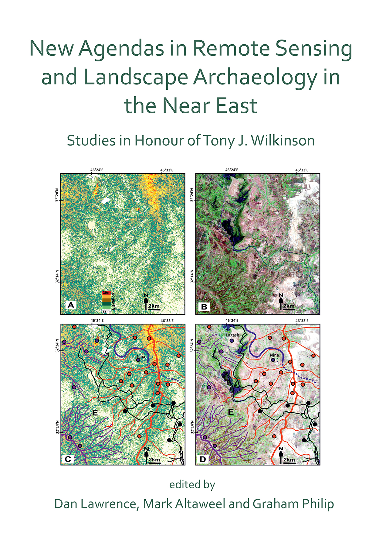
Download Sample PDF
H 290 x W 205 mm
346 pages
181 figures, 22 tables, 10 plates (46 pages of colour)
Published Aug 2020
ISBN
Paperback: 9781789695731
Digital: 9781789695748
Keywords
Remote sensing; Near East; landscape archaeology; satellite imagery; geoarchaeology
Related titles
New Agendas in Remote Sensing and Landscape Archaeology in the Near East
Studies in Honour of Tony J. Wilkinson
Edited by Dan Lawrence, Mark Altaweel, Graham Philip

 Add to wishlist
This volume presents papers in honour of Tony James Wilkinson, who was Professor of Archaeology at Durham University from 2006 until his death in 2014. Though commemorative in concept, the volume is an assemblage of new research representing emerging agendas and innovative methods in remote sensing and their application in Near Eastern archaeology.
Contents
Preface – Eleanor Barbanes Wilkinson ;
List of Principal Publications of Tony J. Wilkinson ;
1. Introduction – McGuire Gibson ;
2. The Search for Hidden Landscapes in the Shahrizor: Holocene Land Use and Climate in Northeastern Iraqi Kurdistan – Anke Marsh and Mark Altaweel ;
3. Social Life and Social Landscapes Among Halaf and Ubaid Communities: A Case Study from the Upper Tigris Area – Marco Iamoni ;
4. Funerary Landscapes in the Land of Nineveh: Tracking Mobile Pastoralists in the Transtigridian Piedmont of Northern Iraq – Daniele Morandi Bonacossi ;
5. Mapping and Modelling the ‘Invisible Dead’: Reconstructing Demographics in the Ancient Near East – Jennie Bradbury and Graham Philip ;
6. The Gorgān Wall’s Garrison Revealed Via Satellite Search: Sasanian Fort Design in Northern Iran – Eberhard W. Sauer, Hamid Omrani Rekavandi and Jebrael Nokandeh ;
7. Investigating Mobile Pastoralist Landscapes in North East Iran: The Contribution of Remote Sensing – Kristen Hopper and Hamid Omrani Rekavandi ;
8. The View from the Steppe: Using Remote Sensing to Investigate the Landscape of ‘Kranzhügel’ in Its Regional Context – Stefan L. Smith ;
9. How the Hollow Ways Got Their Form and Kept Them: 5000 Years of Hollow Ways at Tell al-Hawa – Michelle de Gruchy and Emma Cunliffe ;
10. Hollow Ways in Southern Mesopotamia – Elizabeth C. Stone ;
11. Remote Sensing-Based Approaches to Site Morphology and Historical Geography in the Northern Fertile Crescent – Jesse Casana ;
12. Extrapolating Ebla: Combining Remote Sensing, Survey and Textual Sources to Define an Early State – Dan Lawrence and Sébastien Rey ;
13. Carchemish and the Hittite Empire in the Middle Euphrates Valley – Michael Brown ;
14. Land of Behemoths: Re-Casting Political Territories of the Middle Bronze Age Jazirah – Rune Rattenborg ;
15. Resurrecting Tello (Ancient Girsu): The Topographical Layout of an Early Dynastic Sumerian City – Sébastien Rey and Camille Lecompte ;
16. Resilient Landscapes: The Evolution of Riparian Landscape Studies in Southern Iraq – Carrie Hritz, Nagham Darweesh Al-Hawi, Khaleel J. Al-Sudani, Badir N. Albadran, and Jennifer R. Pournelle ;
17. Subsistence Stability in Irrigating Societies: A Diachronic Perspective from the Jordan Valley – Eva Kaptijn ;
18. Recognition of Ancient Channels and Archaeological Sites in the Mesopotamian Floodplain Using Satellite Imagery and Digital Topography – Jaafar Jotheri and Mark B. Allen ;
19. Early Islamic Water Management in the Hinterland of Raqqa – Louise Rayne ;
20. Conclusion – Dan Lawrence, Mark Altaweel and Graham Philip
About the Author
Dr Dan Lawrence is an Associate Professor in the department of Archaeology at Durham University and director of the Archaeology Informatics Laboratory, a specialist hub for remote sensing and computational approaches to the archaeological record. ;Dr Altaweel is Reader in Near Eastern Archaeology at UCL. He takes an interdisciplinary perspective in his teaching and research, integrating a variety of quantitative methods and fieldwork in his courses and research. ;
Professor Graham Philip is based in the department of Archaeology at Durham. He was one of the first archaeologists to make use of Corona spy photography in his survey work in the Homs region of Syria.
Reviews
'This is a book with many great studies on landscape archaeology in West Asia and I have no doubt that it will become much consulted by all scholars working on those landscapes, and on the archaeology of West Asia in general. I congratulate the authors and editors on this volume.' – Dr. B.S. Düring (2023): Bibliotheca Orientalis no. LXXX 1/2
Archaeopress Publishing Ltd
Summertown Pavillion
18 -24 Middle Way
Summertown
Oxford OX2 7LG
United Kingdom
Tel +44 (0) 1865 311914 | fax +44 (0) 1865 512231 | email:info@archaeopress.com
